
On Wednesday, 10 December, I finally reached a goal I’ve long dreamed of and prepared for; winter-wave-soaring the Cascades volcano crossing from Mt Hood to Mt Jefferson (and return).
<https://www.onlinecontest.org/olc-3.0/gliding/flightinfo.html?flightId=186235709>
First, citations: this crossing has of course been made before by other pilots: Rolf Koenenkamp told me he had soared Hood-to-Jeff in wave rather than thermals (found it July 2011 on OLC). I don't know exactly what Gary Boggs may have done in the Boggsian days at Hood River, but he did establish with the FAA a long-forgotten wave window above Mt. Jefferson and Sisters. And of course Kempton Izuno's flights.
Second, thanks upfront to the fantastic group of folks at Hood River Soaring. In particular, Brian Hart, who came out to the airport to help me assemble, and again later to run wing, and again later to tie down, and to Cory Roeseler for sneaking out of work and delivering the excellent, sporty tow!
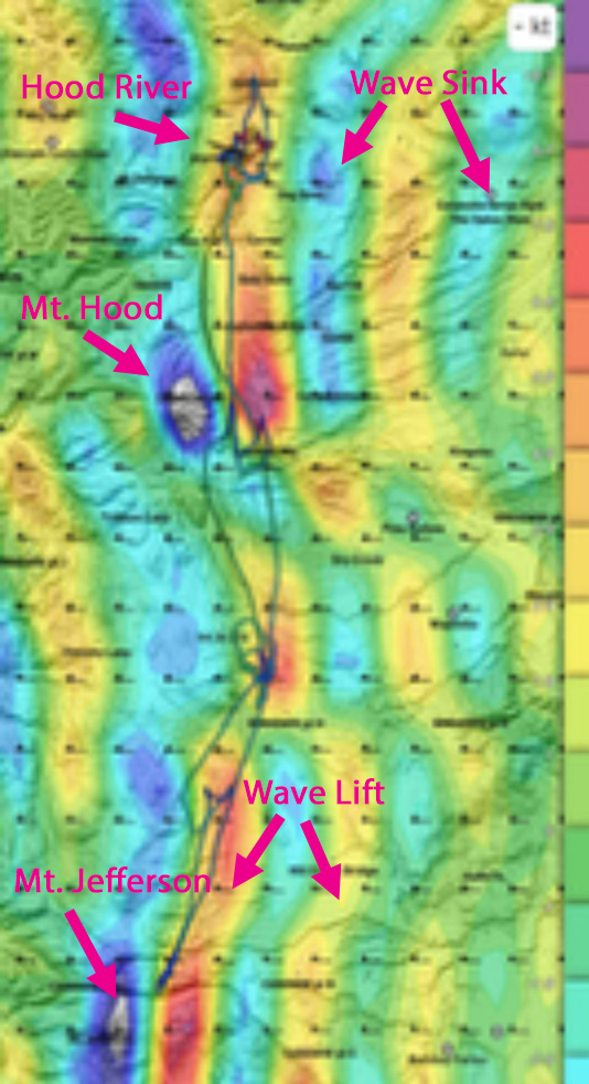
The Skysight wave forecast for Wednesday, 10 December, noon, at 13kft showed great wave from Bergseth (PSSA) in the north to Bend in the south, spanning the visible peaks at Rainier, Adams (& St. Helens), Hood, Jefferson, & more. That the day would have permitted a much bigger flight: had I been pre-assembled and able to launch earlier, having made the crossing to Jeff it should have been easy to turn South Sister. A better, faster pilot than I could have added on Bachelor in the south and Adams as well, for over 400k. St. Helens may have been reachable from Adams, in one brute-force-swoop. Rainier may have been blocked by high cloud. If one was willing to do a crazy one-way-it downwind, Yakima and possibly even Ephrata could have been reachable. Wind speeds aloft were forecast 65+knots.
Below is my flight tracing superimposed on the Skysight wave forecast.
On to the story:
Foolishly, VNE was in the box, not assembled and tied out at HR, so I spent all morning rigging (thanks, Brian!) Cory wrote "Alex’s tow was quite a ride, pulling power back to 2,000 rpm to stay under dark cu clouds at 3-4kft and 80mph, through a blue hole and into glorious wave 3 miles SW of the field at +2kft/min." I released high above the clouds, and started the flight with that day-dreamy radio call: "Seattle Center, GLIDER [pause] NOVEMBER [pause] 302S, xx miles SW of Hood River at niner thousand, climbing, squawking 1202 and, uhhh, letting you know I'm with you on frequency." Experience has suggested that, far from cringe, that seems to be the most constructive way to explain the spontaneous appearance of a damned glider adjacent the HHOOD arrivals into PDX, and they came back, as always, with something along the lines of "Thanks for calling, glad to hear from you!"
The initial climbout in the wave off Mt. Defiance was surprisingly slow, 3 knots on the averager. I took the time to get situated, rode it up above 17kft, and then turned south to cross over the HHOOD arrivals. In the Hood primary I climbed again to 17.5kft; I've learned not to get too high, because even when running at high speeds, say 80+ knots, the primary lift can be so strong on days like this that you can still be climbing and trapped in a velocity/altitude corner! To avoid the force of high-speed spoiler deployment, it's better to leave some height margin to momentarily pull up, slow down, carefully slam the spoilers open, and then perhaps drop the gear (to silence the alarm). Or else push the nose down from 80 to 110 knots, and dare the lift to keep you climbing at that inefficiency-point on the polar -- not advisable!
The main problem that I’ve studied, and experimented with, for Hood-to-Jeff: south of Hood is a nasty sink gap that must be navigated to get to the next lift zone south, often forecast somewhere around "Intersection Hiways 26 & 216”, depending on the wind strength and direction. (Note: this is gap where the Hood Wave Window would be of immense help, once we get the durn thing back!) Now, at this point I'm trying to match my position on my flight computer (XCSoar) with screenshots on my mobile phone from Skysight, predicting where the sink and lift might be. (I should try OpenSoar, which although in beta, attempts to integrate Skysight into XCSoar.)
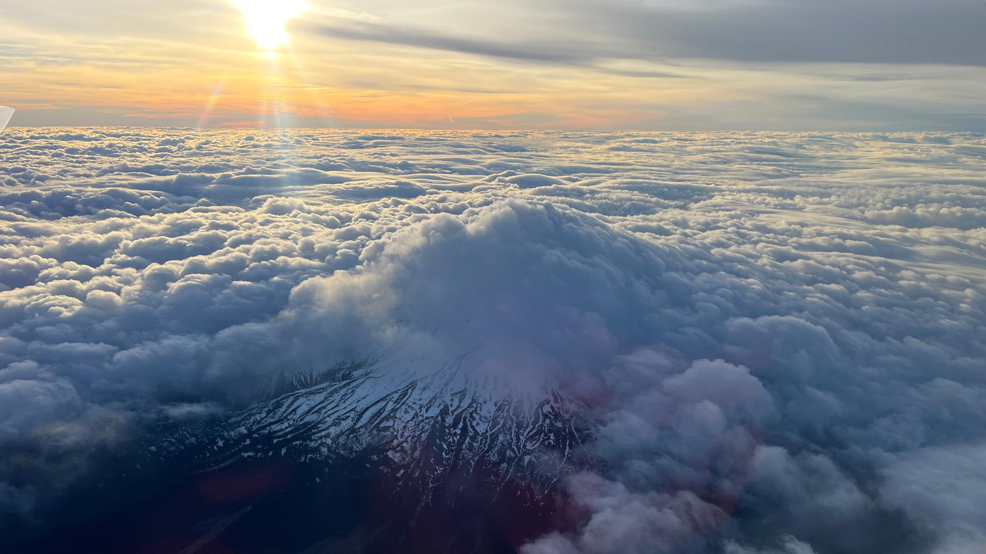

On my first attempt south, at over 100 knots, I ran straight into heavy sink;I fled back to the Hood primary to recharge. I then tried "cutting the corner" closer to Hood, and that worked: I crossed my first Foehn gap, bottomed out around 12kft, and searched/floated around a bit before climbing high again.
At this point I was feeling pretty good: I've conquered what I expect will be the hardest part of the flight, I've made it this far before (in October 2024), but it's much earlier in daylight this time. However, Pine Hollow (landout at my back) looked pretty clouded in. Wapinitia looked clearer. From there, I pushed southwest, and after some strong sink I found the lift again. By this point, I was suspecting something odd about the wind: Skysight forecast was for straight-from-the-west. My XCSoar was calculating wind 270 deg @ 65 knots. But neither my CAI 302 nor my XCVario seemed to have found a wind calculation, even though I did some deliberate circles (ellipses) to help them find the drift. (I don't have a digital magnetic compass yet installed.) And from the lines of the Foehn gaps, the wind looked to have an unforecasted southerly component.
Regardless, I'm fat and happy on altitude, and I can see Jefferson up ahead. However, timecheck: it's 3'clock. Sunset at Hood River is just after 4p. And I'm a long way from home. What do I do? The cautious me says "turn around and work your way home". But I've made it this far -- further than ever before -- and I can see Jeff up ahead. I've dropped markers on the two big upwellings south of Hood, and the forecast is stable. Can I do it in time, get back to Hood River, and get down before sunset? If I can't, I may have divert on the way home to Wapinitia, or The Dalles, and that means another missed day off work. The clincher: if there's one place up ahead where I can practically guarantee to find strong lift that I can climb immediately and rapidly, it's gotta be in the primary off Jeff.
Time is now the constraining resource, not lift and altitude; time is the enemy. Drop the nose, and crank VNE up to 110 knots. Punch through the last Foehn and sink gap, and .... BOOM! into the lift, tanking in the Mt. Jefferson primary! Take a mere two switchbacks, shoot some photos, savor the moment. It's 3:13p, sunset in one hour, and Hood River is 60nm away straight-line. 17.5kft is enough: drop the nose and crank to warp. XCSoar indicating groundspeed reaching 140 knots -- the southerly component to the wind is helping, now. I slowed down but did not stop or turn in the two lift areas between Jeff-primary and Hood-primary. Slowing again at Hood, Seattle Center knows I'm heading for HR, happily adjusts the airliners' courses a little ("turn another 10 degrees, please") asks me if I'm going to turn for climb -- nope, "direct to Hood River". Airliners ask "how high is that glider again"? Finally, I'm over Ken Jernstedt, it's 3:43p, still 10 kft and there are plenty of big blue holes! Final call to Center to request frequency change and say thank you, then pull full-on Glasflugel trailing-edge spoilers and down we go. Through the rotor ... and then remember how to land (it's been a few months). Quiet and empty at HR, the shadows long, and a solo push through wet grass back to the tiedowns.
A note on speed: the straight-line distance home from Jeff-primary to Hood River airport was about 60 nm, flown in 30 minutes. That puts the speed made good I think at around 120 knots / 220 kph (and my real course was not a straight line, to return via the known strong lift points). OLC indicates my ground speed reaching 280kph at points. Definitely kept an eye on the VNE-decrease-with-altitude-chart!
To close, some brief notes on safety and equipment: first, landouts: I had airport options at The Dalles, Pine Hollow, Wapinitia, Madras, and (had I continued further south) Redmond and Bend. I have an Inreach, bluetoothed to my phone, through which I can obtain TAF/METAR updates via satellite (although I could still just make out the HR ASOS all the way from Jefferson). If all else fails, the Mosquito has VNE-limiting dive brakes. My primary oxygen has the duel-stage regulator upgrade, so the full tank is usable down to empty, and I run the EDS on "Flood" as necessary with a continuous-reading, vibrating pulse oximeter (O2Ring). I have a small backup bottle. My pilot relief plumbing includes a Y-valve to blow the line clear after each use to prevent freezing up (gee, that's fun), and I carried 4L of liquid. The freezing level was very high for this time of year (forecast 12-15kft?), so this flight was actually less physiologically challenging than previous winter wave flights. All in all, this flight was the culmination of several years of thinking and practicing winter wave XC and risk-management. I'm very happy to share more about that with anyone who wants to hear about it: winter wave carries (I believe) risks beyond normal XC, but mitigable with preparation.
